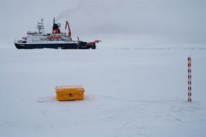

The MOSAiC Expedition, led by the Alfred Wegener Institute, was a year-round operation of the RV Polarstern, which drifted with the sea ice across the central Arctic from September 2019 to October 2020. A distributed regional network of observational sites was set up and as part of this 28 SIMBA units were deployed on the sea ice.
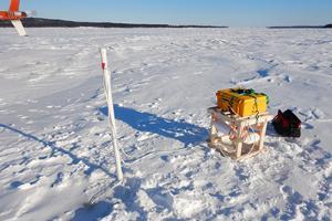
A typical deployment consists of a yellow case, housing the controller unit, communications, and batteries. A 5m thermistor chain is then deployed through an auger hole in the ice and frozen into place to collect snow, ice, water, and air temperature data.
The SIMBA units are compact and portable, which allowed them to be installed by a small deployment team. The setup is very quick and simple, with an estimated 20-30 minutes required to fully deploy each unit on the ice. Once deployed, the units were left to collect data and return this via Iridium to an online data portal.
The SIMBA units were used to study sea ice mass balance data, sea-ice drift data, and temperature profiles of the snow, air, ice, and water. This also allowed the interfaces between these materials to be studied by the scientists.
Data was collected multiple times a day with each unit being deployed for weeks and months at a time.
To view SIMBA data from MOSAiC and find out more about the expedition please use the following links:
https://mosaic-expedition.org/
https://www.meereisportal.de/en/
To view publications using SIMBA data from MOSAiC please click here.
With thanks to the Alfred Wegener Institute and collaborating parties on the MOSAiC Expedition.


Monitoring River Ice on the Churchill River
The Churchill River Monitoring project was established after a flood in 2017 where an ice jam flood occurred at the outlet into Goose Bay, causing the evacuation of a nearby community. As such, it was recommended to increase the real-time environmental monitoring and to help achieve this, four SIMBA units were deployed to help study the river ice thickness and contribute to the wider River Flood Forecasting System.
Four SIMBA units were deployed at set points along the river and fitted with flotation devices to aid retrieval at the end of each season.
The units autonomously return data every 6 hours, minimising the risk to personnel by reducing the number of visits onto the ice. The SIMBA units work alongside helicopter-mounted ground penetrating radar and manual measurements to determine the river ice thickness throughout the season.
The SIMBA units have been retrieved and reused for multiple winter seasons, with thermistor chains and batteries being replenished as required.
To combat the faster flowing river water a wider thermistor chain was developed, providing additional strength and support. Since its creation, this wider chain has also been successfully used to study lake ice and snowpack properties.
To find out more about this project (Lynch et al, 2021) and the IceSight app, please use the following links:
https://cripe.ca/docs/lynch-et-al-2021-pdf
https://www.churchillriver.app/
With thanks to C-CORE and the Government of Newfoundland and Labrador IceSight App