
It collects measurements between manual surveys and transmits the data remotely throughout long-term deployments. SIMBA observations can complement surveys, models and other monitoring systems, providing site-specific information for operational planning, forecasting and research.
SIMBA provides long-duration measurements for operational sea-ice monitoring, polar research, environmental observatories and scientific expeditions. It records temperature profiles through air, snow, ice, and water, providing data to identify changing interfaces and investigate snow depth, sea-ice thickness, mass balance, and heat flux.
Applications may include:
SIMBA provides continuous, site-specific measurements of ice conditions on rivers, glaciers, lakes and reservoirs. Temperature profiles through air, snow, ice and water can be used to investigate changes in ice thickness and interface positions between manual observations. The data can complement flood-warning programmes, meteorological observations, hydropower operations, models and climate change research.
Applications may include:
SIMBA provides continuous, fixed-site measurements from ice roads and winter-access routes between manual inspections. Temperature profiles can be used to investigate changes in ice thickness and interface positions over time, while satellite or mobile transmission provides access to measurements from remote sections of a route throughout the deployment. SIMBA data can complement manual surveys and other monitoring methods used to inform access planning and operational decisions.
Applications may include:
SIMBA provides continuous, site-specific measurements for maritime and port operations affected by sea ice. Temperature profiles through air, snow, ice and water can provide information on local ice conditions, while GPS positioning can be used to monitor the location and movement of drifting sea ice. The data can complement satellite observations, regional ice information and other monitoring systems where a specific site requires closer observation.
Applications may include:
SIMBA gives consultancies a proven, configurable monitoring device that can be used across a wide range of projects. The system can be adapted to different sites, measurement requirements and deployment periods, allowing the team to build familiarity with one technology and apply it across multiple client projects. SIMBA data can be combined with surveys, models and remote-sensing data, with raw data available for independent analysis and client reporting. Technical support is available throughout configuration, testing and deployment.
Applications may include:
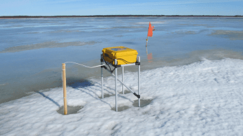
The Churchill River Monitoring project was established after a flood in 2017 where an ice jam flood occurred at the outlet into Goose Bay, causing the evacuation of a nearby community. As such, it was recommended to increase the real-time environmental monitoring and, to help achieve this, SIMBA units were deployed to help study the river ice thickness and contribute to the wider River Flood Forecasting System.
The ICECAPS-ACE project is an international scientific research programme based at Summit Station, Greenland. As part of this work, two Snow Ice Mass Balance Apparatus (SIMBA) units were deployed to provide high-resolution temperature measurements across the snow-air transition zone. The measurements collected by the SIMBA units form part of the wider observational programme and are published by the Centre for Environmental Data Analysis (CEDA).
